


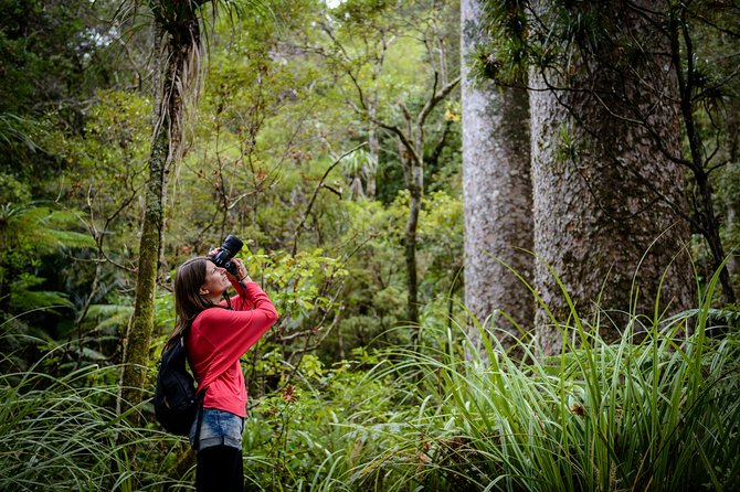
PHOTO: Waipoua Forest in Northland
The huge 25,000 acre plus area covered by Waipoua Forest in Northland is a massive archaeological treasure trove, where once a large population lived, gardened, worshipped, raised their families and died. The stone structures in the forest had been noted and written about by early Europeans, who wondered about the stone builders who had lived there. In 1983 archaeologists from Auckland University were employed by the NZ Forest Service to investigate and document these ancient structures, prior to tree felling in the area. The area under investigation was limited, confined to about 500 acres and split into five sections on both sides of the Waipoua River. It was a ‘drop in an ocean,’ but a start, a chance to document and protect the country’s heritage, to tell the people of New Zealand about an ancient civilisation, predating Polynesian settlement and acknowledged as such by the Pacific voyagers who came after them.

But most of the people of New Zealand do not know what was found in Waipoua Forest over the three year investigation, at a cost to the taxpayer then of $500,000. The detailed mapping and notes of the complex of stone walls, hearths, stone structures defined as altars by the archaeologists, incised obelisks, petroglyphs (rock carvings), standing stone circles, circular stone mounds and stone-lined waterways was instead sent away to remain hidden under a 75 year embargo, restricted until 2063. In 1988, archaeological records on the Waipoua Forest excavations were transferred from Kaikohe to the National Archives in Auckland. The Transfer of Archives form states: “Prior consultation requires approval of the Te Roroa-Waipoua Archaeological Advisory committee or other appropriate subsequent Te Roroa authority.” Te Roroa iwi around that time were engaged in a land claim of the Maunganui Bluff and Waipoua No 2 block with the Waitangi Tribunal. The transfer agreement was modified to include a 75 year moratorium and signed by DOC archaeologist Michael Taylor. It specified a 14 page index identifying all the material to be embargoed.
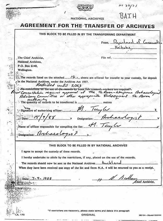
The much discussed “Embargo” document signed by Archaeologist, Michael Taylor and accompanying 14 pages of “something”, which neither the general public nor bona fide research workers were permitted to view until the year 2063. The document states, in the handwriting of Michael Taylor, that ‘Prior consultation requires approval of the Te Roroa- Waipoua Advisory Committee or other appropriate subsequent Te Roroa authority’. The printed line, which would allow bona fide research workers access to the information has been crossed out and overwritten with, ‘restricted until 2063’. The overall intent of this document, as the covering-page for a body of archaeological information deemed “top secret”, could not be clearer.
At the end of the archaeological excavations, all public access to the area was denied. Visitors wanting to see the stone artefacts were turned away. DOC denied access requests by historians and archaeologists, while members of the public were threatened by certain locals when they went to view the ‘stone city.’ Reasons given by DOC was that the area had been declared tapu and that it was under a Waitangi Treaty claim. Meanwhile, people who knew what was hidden in the forest waited for the release of the report on the excavations. They knew it was a significant site for the history of New Zealand. Noel Hilliam was with a group who had seen some of the radiocarbon dating data. He heard Ned Nathan (Te Roroa) exclaim “that’s 500 years before we got here!” (‘We’ referring to Maori)
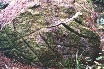
The deep, fissure marks on this boulder were done by stone tools. It might be that the grooves are the result of adze sharpening and fashioning. There are many such incised boulders in the forest and they might represent some form of pictograph.
In 1996, archaeological researcher Dr Gary Cook successfully challenged the legality of the embargo. Submissions to the Ombudsman lead to the release of the large body of material, but the radio carbon dates were absent. When questioned as to why the information had been hidden, The New Zealand National Archives stated that there were no access restrictions, but after numerous Official Information requests from people all around New Zealand, Associate Minister of Conservation the Hon. Phillida Bunkle confirmed that between 1988 and 1996, Te Roroa authorities fully controlled the archaeological results. She wrote: “I am advised that the papers referred to in the recent documentary were lodged in Archives without the knowledge or authority of the Department of Conservation…my department has no specific information about the restriction placed on the papers by a member of the local iwi, Te Roroa and lifted in 1996. Until then, I understand, only persons with written permission from the Pahinui Marae, near Dargaville, could gain access to the archival material. This has not been the case since 1996. In summary, the papers referred to in the recent documentary are readily available. The copies lodged with National Archives were released from formal embargo in 1996.”
An ancient wall, this one protruding significantly above the humus layer. Other long, low crib walls now barely rise above the forest floor. There are also lines or circuits of boundary boulders, sectioning off particular areas.
But the files finally released were incomplete. There was a vital report missing from samples tested at the Radiocarbon Testing Laboratory at the University of Waikato. Data already released showed material from the excavation fell within the known occupancy of modern Maori.(The official Government date for the arrival of the first people, from Eastern Polynesia, is the late 13th century. Kupe is said to have featured in the 14th century.) But there was no sign of the data showing the much earlier date. Then, in a strange twist, this file surfaced, sent anonymously to Hokianga historian Joan Leaf, who with Noel Hilliam, had complained about the lack of access to the information in a Radio Pacific interview in 1996. The data from a food midden at Motuhuru showed a True Age date of 950 plus or minus 50. This was the missing report exclaimed over by Ned Nathan, on a 1000 year old cat’s eye shell, collected from a midden by Michael Taylor in 1986. The readings confirmed there were people living in the area now called Waipoua Forest when the ancestors of modern Maori arrived. On the same file was another reading of a pipi shell, collected from a midden excavated at Kokohuia, Omapere by Michael Taylor. It also carried the radiocarbon date of 900 plus or minus 50 years.
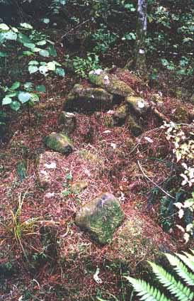
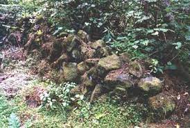
Another of the hundreds of enigmatic stone heaps that archaeologists registered as “purpose built” structures. Again, this was probably once a “Beehive House” dwelling
The figures are finally in but the truth is still out. Out of the public eye and out of official, public acknowledgement of the huge historic site that is sheltered by the Waipoua Forest. What lies hidden there speaks of a long ago race of stone builders and the ancient Waitaha Tawhito who followed and integrated to form one people. Even with many stone structures buried in a deep humus layer, the vast area where the ancient people lived is awe inspiring. At one site alone, an extensive garden area is surrounded by collapsed stone dwellings and places of worship, speaking of thousands living there in peace for a great length of time. Boundary markers separate various garden plots, with stone cairns set at even distances to provide growing places for yam. The gardens run down to the Waipoua River, where a unique microclimate and soil types would have encouraged kumara and gourd to thrive.
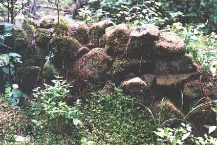
Another section of “stacked stone” wall and one of the 2000 structures, on 600 sites within the 500 acres of archaeological assessment.
Amid the gardens, an astonishing discovery was made, a massive stone bearing a rectangular pattern of deeply cut grooves. At the base of the stone is one single curved line. The straight lines could have been caused by natural weathering and cracking, but this curved line was clearly shaped by a human hand. What does this ancient petroglyph signify? It looks uncannily like the carved shape of a sailing ship with its curved base and extended masts. But there is another possible explanation, proposed by Australian archaeo-astronomer Alan Seath. Alan took sightings through a compass and said that the petroglyph was a plan of the gardens, with the curved line indicating the western boundary. He indicated a direction as to where the boundary markers would be found. Within 20 metres a line of low stone cairns arranged in a curve were found, skirting the edge of a gully. On that basis, it seems likely that the other carved lines represented other garden markers. This is an astounding find and yet the petroglyph stone was not mentioned anywhere in the released documents on the DOC Waipoua Forest excavations
SOURCE: Raynor Capper
propertynoise.co.nz to launch real estate industry recruitment site